 |
 |
Gillett Cemetery
|
|
Date Photographed: May 8, 2001
Marked Burials: 1
Volunteer: Les Heinemann
To find the remains of Gillett Cemetery, from the town of Divide on Highway 24 drive south on Highway 67 for approximately 12.9 miles. Turn right onto an unmarked dirt road and proceed through the gated fence 0.18 mile until you reach the crest of a small north/south ridge. Tire tracks can be seen in the grass to the right (north). Follow these on foot for about 250 feet. According to GPS-derived geolocation (accurate to within 10 meters), the coordinates of the one remaining readable marker are 38°47'20.6"N and 105°07'40.6"W. The cemetery is at approximately 10,000 feet elevation.
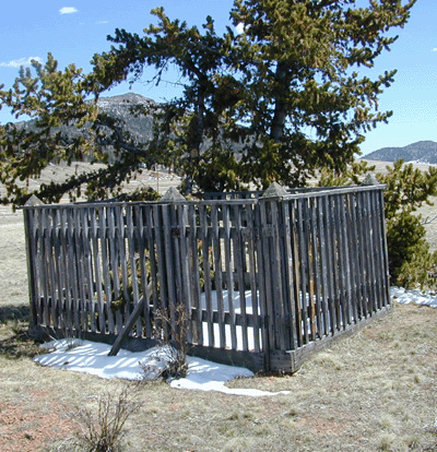
The cemetery is located in the region between a high prairie and forest; the land, which has been used to graze cattle, is covered with natural grasses, small bushes, and evergreen trees. Three plots enclosed with iron fencing remain, although no markers reveal who was buried there. One wooden-fenced plot is in relatively good condition, and others are disintegrating. Scores of sunken graves dot the ridge, especially on the eastern slope. Some graves have been mounded with red brick.
In 2004, Cripple Creek District Museum staff member Jan MacKell noted that Fern Vetter, whose husband Joe Vetter grew up at Gillett, said some people were caught removing marble tombstones at the Gillett cemetery in the 1950s or 1960s. The people were made to take the tombstones out of their truck, but the stones were then mixed up and it was unknown where they were originally located within the cemetery. Shortly after, the marble tombstones were stolen again and never returned.
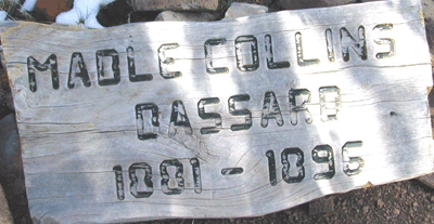
The townsite of Gillett was located northwest of the curve in Highway 67 south of this cemetery. The red brick remains of a Catholic church stand in the field to the south of the road by which the cemetery is accessed. The town was platted in 1894 and the area was deserted by 1920. Some burials were reportedly moved to Mount Pisgah and other cemeteries. The one remaining legible marker is wooden and doubtless not original. It reads:
MABLE COLLINS
BASSARD
1881-1896