![]() Table Rock Cemetery
Table Rock Cemetery
Cut-off Date: 27 May 1997
Number of Burials: 23
Volunteers: Caren Gordon and Nan Oberle, Milton
D. and Mary Lou Lake
Special Thanks: Van K. Hollingsworth, Lucille
Lavelett, Mrs. Howard E. Roberts
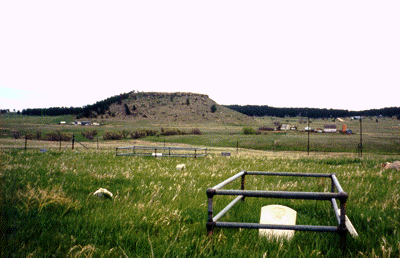
Table Rock Cemetery sits on an open, windswept hilltop in northern El Paso County. It measures approximately 80 by 120 feet and is surrounded by barbed wire strung between metal fence posts. The nearest landmarks are County Line Road on the north, Campbell Road on the east, Walker Road on the south, and Highway 189 on the west. The cemetery is not visible from any of these roads. According to GPS-derived geolocation (accurate to within 10 meters), the cemetery's coordinates are latitude 39°07'05.8"N and longitude 104°41'07.7"W. For permission to access the site, contact Van Hollingsworth, 19750 Campbell Road, Colorado Springs, CO 80908, whose land encircles the cemetery.
All of the information about the cemetery's history comes from two sources: Lucille Lavelett was a descendent of early Monument settlers. Her 1979 book, Monument's Faded Neighbor Communities and Its Folklore, was dedicated to saving the history of the pioneer settlements of northern El Paso County, including Table Rock. The other source is Mrs. Howard E. Roberts. She and her husband descend from early Table Rock residents who are buried here.
The private land on which the cemetery is located was originally part of a ranch belonging to John and Honora Russell, who are buried here with their children. The earliest grave is that of Samuel S. Meek, 1872, although an abstract indicates it wasn't officially a cemetery until April 7, 1896, when one acre was set aside for that purpose. The last burial was that of Harvey Samuel Peterson in 1910. No sexton records could be found, so all information is from the weathered headstones and the above sources.
Table Rock Cemetery data (by plot)